Just Passing Through
06 Mar 2018
A short drive through Charleston’s nearby historic towns
By SUZANNAH SMITH MILES
Ah, Spring! The air is crisp and clean, the sky is bluer than one thinks imaginable and the marshes are turning from a long winter’s grey into bright, vivid green. Indeed, the monotones of the long winter are behind us and the Lowcountry is once again emerging as a multicolored, multiflora wonderland. Now is an excellent time for a leisurely drive down an unrushed back road to soak in the beauty—and history—of the Lowcountry. The area south of Charleston has some wonderful roads for meandering, and these stories tell of the history of places you might pass along the way.
Let’s begin with Walterboro. The town got its start in 1784 after brothers Paul and Jacob Walter, who had plantations near Jacksonboro, went in search of a place for Paul’s sickly daughter, Mary, to spend the hot, disease-prone summer. They set up a small summer community and were soon joined by their two brothers, John and Isaac Walter. Before long, other planter families looking for a healthful summer residence joined them. What was known as “Walter’s Hill” soon morphed into Walterboro. By 1817, the town was the seat for Colleton County. In 1822, the brand new courthouse designed by the talented South Carolina architect, Robert Mills, was open for business. The town was officially incorporated in 1826.
A perfect road for meandering to Walterboro is Highway 64, which takes you through Jacksonboro. This sleepy little crossroads town was named for planter John Jackson, Sr., one of the earliest to settle in the region. This is where the Edisto River divides into two forks—historically known as Pon, a Native American word believed to mean “forks at the river.” Jackson was in South Carolina as early as 1697, eventually receiving grants for a total of 1,700 acres. In 1701 he received a 400-acre grant on the South Edisto River upon where he built his plantation; a portion would later be developed by his heirs as the town of Jacksonboro.
Not far from Jacksonboro on Alternative Highway 17 is the little community with the intriguing name of Round O. The area purportedly takes its name from an early Indian warrior who had a circle either painted or tattooed on his shoulder. This was likely the Cherokee chief named Utossite (d. 1759) who, according to Indian trader James Adair, was given the name “Round O” for the “blue impression he bore in that form.” The name shows as early as 1709, when Thomas Elliott had a warrant for 450 acres “adjoining to the South Side of the Round O Savanna…by lands belonging to Thomas Welch.” Welch, who emigrated from Scotland around 1682, was a well-known Indian trader who established a trading post on his lands. In these early years, this area was considered the frontier.
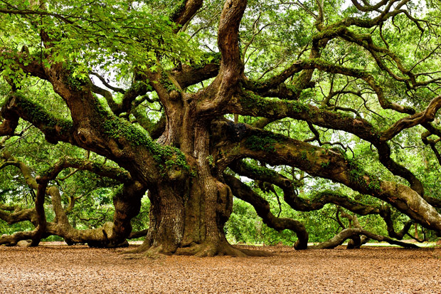
Moving towards the coast, one of the most intrinsically Lowcountry sites is the Angel Oak on John’s Island, located near the intersection of Main Road, Maybank Highway and Bohicket Road. This towering live oak, reported to be in excess of 1,400 years old, is some 65-feet high and has a trunk circumference of over 25 feet. Its largest limb has a length of 89 feet. The Angel Oak stands on property granted to Abraham Waight in 1717, and the area was originally called “Waightland.” The property acquired the Angel name when Martha Waight married Justice Angel in 1810. Today, the Angel Oak is owned by the City of Charleston and is open to the public as Angel Oak Park.
This part of John’s Island was once the land of the Indian tribe called Bohicket, who lived along the shores of Bohicket Creek. The name has been variously spelled throughout history and is shown on Herman Moll's 1711 map as "Bobickcock."
Follow Bohicket Road and it will take you to Seabrook and Kiawah Islands. Seabrook Island takes its name from Captain Robert Seabrook, who was granted the island in the late 1600s. Prior to that, the island was known as Stono Island, so named for the Stono Indians who also lived in the vicinity.
Likewise, Kiawah Island takes its name from the Kiawah, a tribe which has an important place in history for being the people who convinced the original Charles Town colonists to settle near their village on the shores of the Ashley River—which, not surprisingly, was originally called the Kiawah River. Around 1682 the tribe moved their main settlement to the vicinity of the island that now bears their name. In 1699, the island was granted to Captain George Raynor who established the first plantation there. It later came into the Vanderhorst (pronounced Van-dross) family and the Vanderhorst mansion still stands as a testimony to those early plantation days.
The inlet separating Seabrook and Kiawah Islands is called Captain Sams Inlet, so named for Captain Robert Sams (b. 1718). He was a Wadmalaw Island planter and descendant of Englishman Bonham Sams, who first settled in this region in 1694. Sam's Bluff on the Wadmalaw River is also named for this family.
Wadmalaw is also a name of Indian derivation, possibly meaning “crane” or “sandhill crane.” Wadmalaw Island’s "capitol" is Rockville, a charming and historic waterfront village located on the point of land at the convergence of Bohicket Creek and the North Edisto River. The town’s name derives from The Rocks plantation, owned by brothers Benjamin and Samuel Jenkins in the 1700s, which was named for an outcropping of phosphate which jutted like rocks from the bluff along the river. The village of Rockville was established in the late 18th century as a summering place for area planters who built homes along the waterfront, many of which still remain today.
Yonges Island is on the opposite side of the Wadmalaw River and takes its name from Robert Yonge (later spelled Young) who settled plantations here in the early 1700s.
EDISTO ISLAND also takes its name from an Indian tribe, the Edisto, at times spelled “Audusta” and who were known to the early Spaniards as “Oristo.” Just off the Edisto Island mainland is the barrier island called Botany. Once known as Clarke’s Island, it was renamed by Edisto Island planter, John F. Townsend, II, of Bleak Hall Plantation. One story tells that he humorously named the island after the notorious Australian penal colony of Botany Bay, since he would place his livestock on the island where there was no need for fencing. Today the island is owned by the state of South Carolina and open to the public as the Botany Bay Plantation Heritage Preserve and Wildlife Management Area.
Just south of Botany is Edingsville, once a thriving summer barrier island resort. It was named for the Edings family who, during the 1800s, developed the island as one of the most popular summering places for area planters. In its heyday Edingsville had a thriving community of homes, boarding houses, a school and a church. An advertisement in July 1852 touted the island’s Atlantic Hotel which offered “a rare opportunity…to those in search of health and pleasure, to avail themselves of the benefits of this salubrious Atlantic Watering Place.” The island was all but destroyed by the hurricane of 1881. What remained was completely washed away by Hurricane Gracie in 1959. Today, Edingsville is not much more than a thin strip of sand.
There’s far more to see than can be mentioned here and an abundance of roadside historic signs to further explain the region’s history. Perhaps the best advice comes from the great Yogi Berra who said, “When you come to a fork in the road, take it!” Happy meandering. You won’t be disappointed.